FG Deploys Drones for High-Tech Digital Mapping of Abuja
FG Deploys Drones for High-Tech Digital Mapping of Abuja
By Achimi Muktar
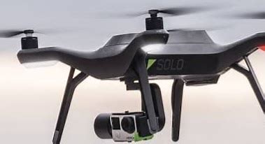
In a groundbreaking move, the Federal Government is set to launch a digital drone mapping project in Abuja, a move that promises to transform urban planning, agriculture, and security operations in the nation’s capital.
The Office of the Surveyor General of the Federation (OSGOF) has secured all necessary approvals from the Office of the National Security Adviser (ONSA) and the Nigerian Military, paving the way for the full-scale deployment of advanced aerial technology.
Why Drone Mapping?
The Surveyor General of the Federation, Abduganiyu Adeyemi Adebomehin, described the project as a game-changer for Nigeria’s urban development, land administration, and environmental monitoring.
“Accurate geospatial data is the backbone of any modern city,” Adebomehin stated. “This project will enhance infrastructure planning, disaster management, and even agricultural development in Abuja.”
Safety and Security Measures
At a high-level briefing held at OSGOF headquarters, key stakeholders, including the Nigeria Civil Aviation Authority (NCAA) and the Federal Capital Development Authority (FCDA), discussed Safety Operational Risk Assessment (SORA) protocols to ensure a smooth and secure rollout.
Surv. Hafiz Azeez, Head of Photogrammetry and Remote Sensing at OSGOF, assured the public that privacy concerns would be strictly managed, while NCAA’s General Manager, Capt. Maikano Wilson, emphasized the importance of coordinating airspace regulations with the Nigerian Airspace Management Agency (NAMA).
When Does Mapping Begin?
Preliminary site assessments are already underway, and full-scale mapping operations are scheduled to commence next week.
Frank Pichel, team lead from Place US, a key partner in the project, reaffirmed the team's commitment to complying with environmental and regulatory standards.
What This Means for Abuja Residents
For Abuja residents, this project means:
✅ Better city planning and road infrastructure
✅ Improved agricultural mapping for food security
✅ Enhanced security monitoring and emergency response
✅ More accurate property and land registration
With Nigeria embracing cutting-edge drone technology, Abuja is set to become one of the most digitally mapped cities in Africa—ushering in a new era of smart urban development.


